Monument 5X Beringen in Miersch, Luxembourg
Apr. 22nd, 2026 10:00 am
Beringen (known as Biereng in Luxembourgish) is a small village in the municipality of Mersch. It is located 30 minutes' drive north of Luxembourg City. In the heart of the village stands a curious monument consisting of intertwined 'B' surrounded by flags. A plaque at the foot of the monument indicates that it is the 5x Beringen Monument, which was inaugurated on 9 July 1989. It symbolises the bond that unites the villages of Beringen (Belgium); Beringe (the Netherlands); Behringen an der Wipfra, Behringen and Behringen (Germany); Beringen (Switzerland); and Beringen (Luxembourg).
The history of the friendship between these European villages with almost identical names began in 1956 with the first contact between the Belgian and Dutch villages. In 1959, delegations from the seven villages met for the first time in Belgium (this year officially marks the creation of '5X Beringen International'). Since 1969, the seven villages have competed against each other in a series of games every three years.
It was during one of these games, held in Luxembourg from 7 to 9 July 1989, that this monument was unveiled. In theory, each village hosting the games should have erected its own monument from 1980 onwards. However, there is no evidence to confirm that the other six monuments were ever built: only information panels have been installed in some villages.
This monument commemorates the remarkable friendship that has united these seven villages from five different countries for over half a century.
Getting poked .. aftermath
Apr. 22nd, 2026 09:50 amWell, yeah. My immune system went, "Oh yeah? You wanna fight?" When my immune system punched out the fake Bad Guys it left me all achy and sore and tired. Nothing serious, just achy and sore. This is normal. Then yesterday I mowed the lawn which left me even more sore and achy. I'm a little better today.
I'd rather be sore and achy for a few days than have COVID or pneumonia.
Gas prices has risen from 3.88 per gallon before the "not war" to 4:10 per gallon. I haven't compared the groceries yet but I'm expecting even more high prices. If tRump keeps making these kinds of 'deals' with Iran we're all going to go bankru0t.

Gorgeous
Apr. 22nd, 2026 02:27 pmPeonies survived the frost event.
Apr. 22nd, 2026 07:41 am( More news? )
O Maidens in Your Savage Season, volume 2 by Mari Okada & Nao Emoto
Apr. 22nd, 2026 08:51 am
Can the salvation of the Literature Club be something as simple as blackmail?
O Maidens in Your Savage Season, volume 2 by Mari Okada & Nao Emoto
Why do some people act on climate change while others stay silent?
Apr. 22nd, 2026 08:00 amso I started yapping and this got long
Apr. 22nd, 2026 02:37 pmMy sister's been hogging the washing machine since Saturday and it seems like it may or may not rain this or that day over the next few days, so I probably need to steel myself for doing a quick load when she leaves later, so I'm sure to have clothes to wear (that I like and are comfortable... if you looked at my closet you'd be like, what the fuck, but unfortunately my cold/cool weather rota does not encompass even half of that, and it is still cool enough indoors for long sleeves) on Saturday. If I can, I'd also like to start individually washing that winter blanket, the charcoal gray blanket I'm currently using, my green winter coat, and my house shoes. Either pair. Though I may throw the one I haven't been wearing in the trash at this point, god knows how many times Ciri's peed on them by now.
Ciri was in heat last week and I was exhausted the whole time, to the point that I felt drunk when I went to the store Saturday morning. It was kind of funny because my mom had been hypocritically side-eying my picking up 5% abv cocktails in a can the day before, but also: not pleasant. I'm slowly recovering from that, but the nightmares aren't helping. Neither are the bouts of depression.
-
I've been experimenting with extremely low-grade alcohol for a couple of weeks -- and by low I mean "I don't think this counts as breaking sobriety," because the tipsiest I've felt has been 'unexpectedly happy,' twice -- to see how my body takes to it now it's been off it for three years, and also so I could try a drink I saw at Primaprix that looked right up my alley except for the 5% abv. It was delicious. They no longer stock it, of course. ( More chatter about this. )
-
Three episodes behind on The Pitt, caught up on 9-1-1 (Buck ;__;) and decided to finish 9-1-1 Lone Star for some reason. I have two episodes left and I assume they're gonna make me cry again so I've been putting it off a bit. This show is a telenovela. For all the NDEs in 9-1-1, at least you can kind of assume things will turn out okay, with one glaring exception. Season 4 of Lone Star was just melodramatic hit after hit, and Judd has been depressing in season 5. Carlos, too, to some extent. I do still really love Nancy and Marjan though. And TK and Carlos's relationship. And Paul. ( Ramble/rant, with spoilers. )
Anyway. I am trying to convince my brain mice to let me do things. I just wanna make maps and edit pictures and the mice are like, "what's that? We don't know how to open an editor suddenly." I'm halfway through Trespasser on Dragon Age: Inquisition, where I am missing most of the trophies for some reason? I'm pretty sure I did the DLC last time, but who knows. It was 2020. I accidentally locked myself out of a bunch of companion quests, but I'm just not putting myself through this game again. It would be so goddamn replayable if combat wasn't so tedious. I have it on easy! It should not take this long to defeat a bunch of bandits! At this point if they had an accessibility 'one-shot enemies' option I would take it. Goddamn. Let me shoot them in the head. Let me shoot them dead in the head, specifically. At least Veilguard let me aim.
I'm very pleased I made a guy and experienced the Dorian romance, though. He is just delightful.
A premapped course, a crew of handlers and a world-beating time: here’s what this Beijing half marathon reveals about how far humanoid robots have come—and how far they haven’t
Fresh takes on Apollo’s famous “Earthrise” and “Blue Marble” images showed off our planet’s beauty just weeks before Earth Day
No Name Pub in Big Pine Key, Florida
Apr. 22nd, 2026 08:10 am
Dollar bills blanket nearly every inch of the walls and ceiling of this Big Pine Key dive, layered so thick in places that the original surfaces have disappeared. Some are neatly pinned. Others curl at the edges after years of humidity. Many are signed, dated, or decorated with messages from visitors who wanted to commemorate their visit.
The building dates back to the 1930s and originally served as a general store, then a bait shop for local fishermen. For a few years, the upstairs storage room was even converted into a brothel, but after several years the brothel shuttered. (The fishermen were reported to be better looking than the ladies.)
The space has since evolved into a bar and restaurant that’s one of The Keys’ most beloved hangouts. Locals and tourists alike line up for its quirky pizza toppings (Caribbean chicken, white shrimp, furry fish, etc.), crispy coconut shrimp, and smoked fish dip. Their homemade key lime pie—filled with whipped cream—often steals the show with its uniquely light and creamy texture.
The tradition of covering the walls with dollar bills started decades ago when patrons started leaving signed notes behind, pinning them up as souvenirs. Every so often, the staff removes portions of the bills and donates the proceeds to local charities, turning this strange tradition into something quietly generous.
Marathon Air Museum in Marathon, Florida
Apr. 22nd, 2026 08:05 am
At the Marathon Air Museum in The Florida Keys, the usual museum distance between visitor and machine shrinks fast.
Operated by Chapter 1241 of the Experimental Aircraft Association (EAA) at Marathon’s airport, the site is shaped by people who love airplanes enough to keep telling their stories. The museum is even located inside a working airport hangar, giving visitors the feeling of stumbling into aviation’s back room.
In a region better known for bridges, boats, and turquoise water, the Air Museum offers a unique, hyper-local history of flight. The biggest draw of the museum is perhaps the Beech C-45 Expeditor, used in the U.S. Air Force during WWII.
Other historic aircrafts, models, and aviation memorabilia fill the space—plus, an old-school fire engine—and volunteer guides are always around to give guests the inside scoop on each artifact’s unique past. If you’re lucky, you may even get to sit in the pilot seat of one of the aircrafts or see a few planes take off up close.
Key West Garden Club in Key West, Florida
Apr. 22nd, 2026 07:54 am
On the southern edge of Key West, the Garden Club occupies West Martello Tower, a Civil War-era coastal fortification originally meant to support Fort Zachary Taylor. The fort was never fully completed, and over time its military purpose dissolved into a string of different uses, including troop quartering, storage, signaling, radio operations, and an anti-aircraft battery site.
By the late 1940s, the structure had deteriorated so badly that there was pressure to demolish it. Instead, local advocates helped save it, and the Key West Garden Club entered into a land-lease agreement with Monroe County. In 1976, the tower was recognized as a historic site and listed in the National Register of Historic Places.
Visitors can wander through arched brick passageways and former fort spaces now softened by orchids, bromeliads, and all manner of tropical plants. There are also special garden sections for cacti, prehistoric plants, and even butterflies!
A small hill takes visitors through fields of vibrant native wildflowers and provides a great view of the nearby Higgs Beach. Throughout the floral-filled space, the fort’s vaulted ceilings, gun mounts, and old military fabric remain visible among the greenery.
Jules' Undersea Lab in Key Largo, Florida
Apr. 22nd, 2026 07:45 am
Sitting in a lagoon at MarineLab Undersea Park in Key Largo, this pressurized habitat is a compact world of portholes, bunks, and machinery with an uncanny feeling of domestic coziness.
MarineLab describes it as the world’s only underwater habitat where recreational divers can experience living and sleeping underwater, and the broader organization traces the habitat’s story back to La Chalupa, an earlier undersea research station in the Caribbean. Over time, the habitat shifted roles from research station to hotel and now to an educational attraction operated by the nonprofit Marine Resources Development Foundation.
A three-hour visit to the lab includes a guided dive through the lagoon and entry into the habitat itself. The overnight “Aquanaut Adventure” stretches the fantasy further with meals, free time inside, and the wonderfully absurd promise of hot pizza delivered underwater.
Head-on fish skeletons, a normal thing you see all the time in real life
Apr. 22nd, 2026 11:24 amHeathcliff, 4/22/26
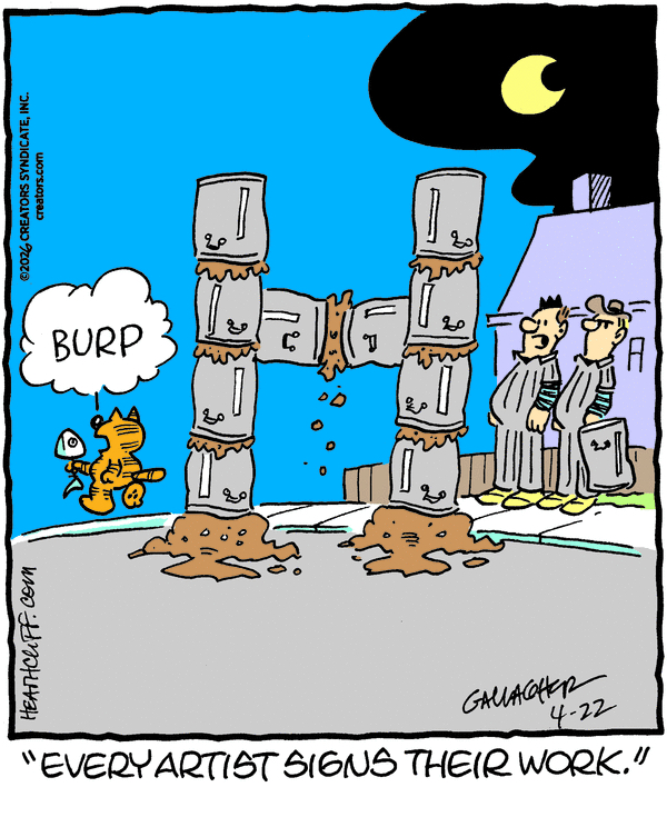
One thing I love about newspaper comic strips is that they’re full of visual signifiers that are multiple generations out of date at this point but just kind of stick around out of inertia, which would confuse any young people reading them if young people still read the comics. Until the medium is truly dead, everyone will have bone-in hams in their refrigerators and everyone will simply dump their garbage into a metal can, without even putting it in a plastic bag first, until it merges together in a grotesque brown slurry. Did you know that garbage slurry is viscous enough to serve as a powerful adhesive? Heathcliff does, and he’s made it his artistic medium.
Rex Morgan, M.D., 4/22/26
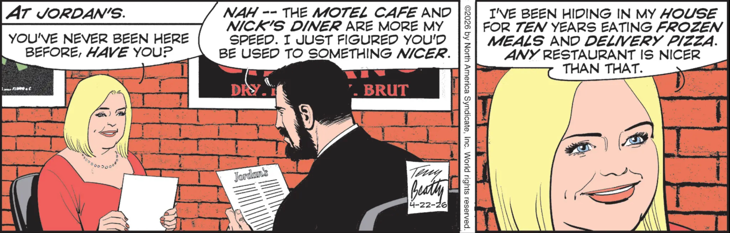
I’m not sure what’s sadder: that Mud only likes two restaurants in this town where he hangs out a lot, one of which just reopened for the first time in years, or that Mae Mae lived in Los Angeles, where some of the best and most interesting restaurants in the country do delivery via DoorDash, and yet has ordered nothing but pizza for the last decade.
Mary Worth, 4/22/26
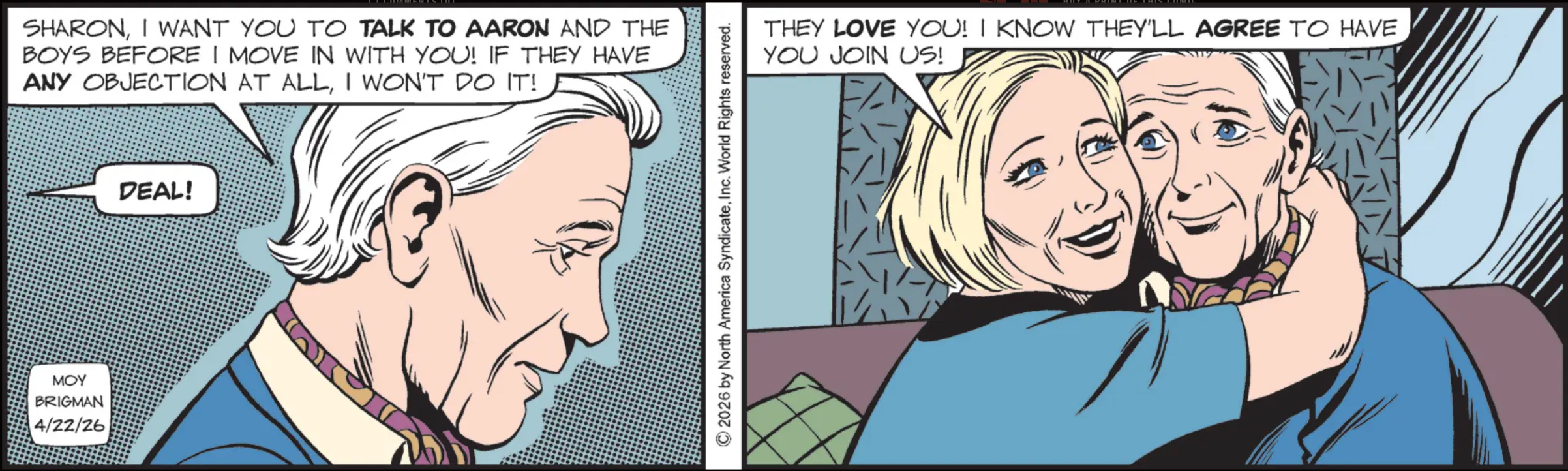
[ONE WEEK LATER]
“Dad, I’m not sure how to say this, but I talked to Aaron and the boys, and, well…”
“Oh, don’t even worry, dear. I’m actually going to be moving in with my new girlfriend, Busty. There’s just the small issue of working out the complications with her visa!”